 Ground Penetrating Radar (GPR) has been used for a number of years, primarily for scientific research. Recent advances in GPR technology have expanded its applications for numerous land uses.
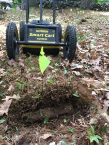
Our Ground Penetrating Radar will provide accurate horizontal and vertical location of subsurface targets on your site. In addition to real time field assessment, a plan view with associated elevations can be readily provided and overlaid on base maps in various datums to meet your needs.
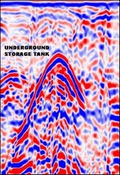
GPR provides subsurface surveys that are non-destructive and non-intrusive. Our technicians can accurately map and create a 2D imagery of subsurface metallic, non–metallic, concrete, clay tile and plastic structures. By obtaining subsurface information early in the planning phases of a project allows the incorporation of existing features into the design thus reducing costs and avoiding expensive delays during construction.
Individuals planning excavation activities will save time and money by having accurate locations and depths of underground features.
Typical GPR applications include:
- Utility locating and mapping
- Condition assessment of various-diameter utilities and drainage features
- Underground storage tank and buried drum locating
- Subsurface assessments and encroachments
- Concrete assessments (rebar spacing, thickness, voids)
- Subsurface void and sinkhole locating
- Examination of structural integrity of roads
- Archaeological site location
- Bridge deck assessment
- Overall thickness of asphalt (flexible) or concrete (rigid) pavement
- Railway track substructure evaluation
- Aviation facility inspection
- Septic system location
- Saltwater infiltration
- Grave site identification
- Ice profiling
- Snow depth profiling